


The Kosasthalaiyar, the river most Chennai residents rarely think about, is more than twice as long as the Cooum. The Water Resources Department puts its total length at 136 km, against about 65 km for the Cooum and 42 km for the Adyar on the Chennai Rivers Restoration Trust pages.
Inside the city the order flips. The Cooum spends 20 km within city limits, more of its course than any other waterway here, while the Kosasthalaiyar runs only 16 km through the metropolitan area, across the far north. The graphic below lays them side by side on one ruler.
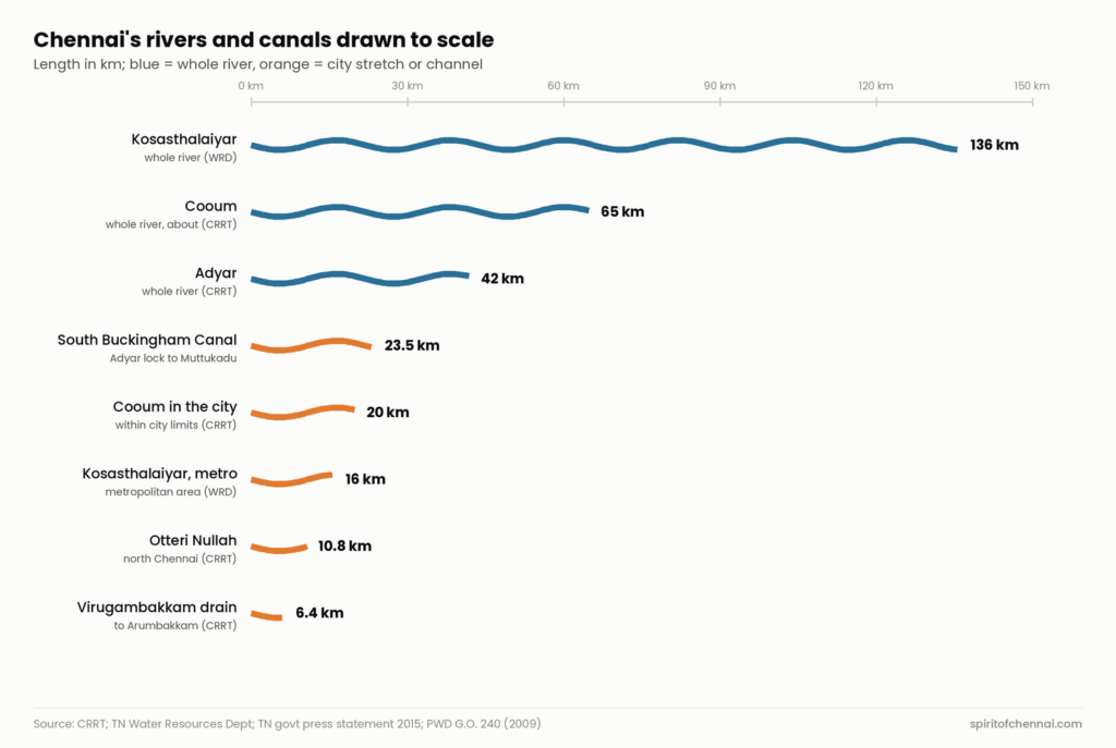
- Every line uses the same scale, so a line twice as long is a waterway twice as long.
- Blue lines are whole rivers. Orange lines are the parts inside Chennai or its metropolitan area, plus the city’s canals and drains.
- Each length comes from a named government document; where documents disagree, the table below gives both.
Three rivers, very different shapes
The Cooum rises from the surplus course of Cooum tank in Tiruvallur district and runs east for about 65 km, CRRT says, through a narrow basin of about 505.88 sq km. Close to a third of its length lies inside the city, which is why it shapes so much of central Chennai.
The Adyar is shorter but drains a wider area. A 2015 Tamil Nadu government press statement gives it 42 km and a catchment of 808 sq km, and says it runs about 12 km past its Thiruneermalai confluence before reaching city limits. CRRT traces it from Adhanur lake near Guduvancheri through Kancheepuram, Chengalpattu and Chennai districts, with Chembarambakkam’s surplus joining near Thiruneermalai.
The Kosasthalaiyar is the giant. Its catchment spreads over Vellore, Chittoor, Ranipet, Tiruvallur and Chennai districts, and in flood it can carry about 50,000 cubic feet a second, the Water Resources Department told the National Green Tribunal in 2023.
Share of the Adyar’s catchment that lies above Chembarambakkam tank: 358 of 808 sq km, according to the 2015 government statement.
The city’s own channels
Within Chennai, the smaller drains matter as much as the rivers. CRRT gives the Otteri Nullah in the north 10.8 km and the Virugambakkam to Arumbakkam drain in the south 6.4 km. The South Buckingham Canal works sanctioned in a 2009 Public Works order run 23.5 km by chainage, from the Adyar South Lock to the Muttukadu backwater.
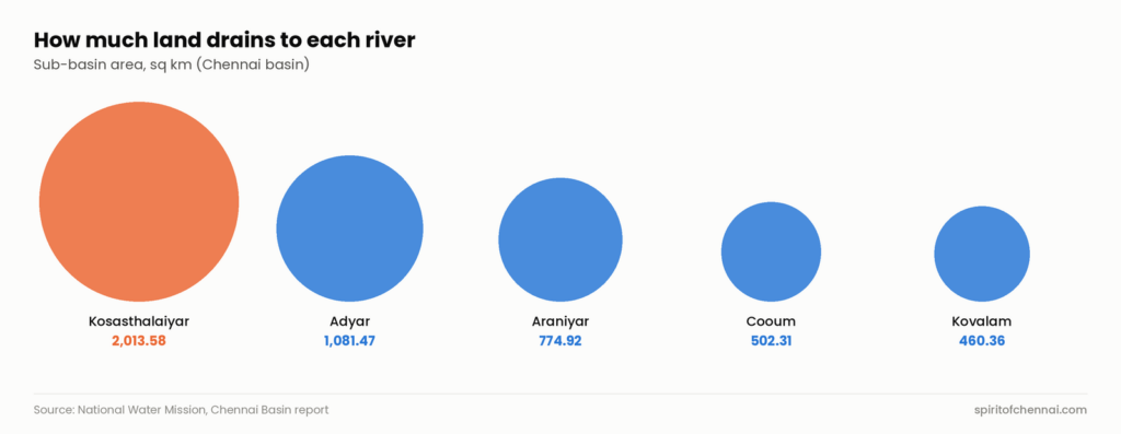
Basin size tells a different story from length. The National Water Mission’s Chennai basin report puts the Kosasthalaiyar sub-basin at 2,013.58 sq km, about four times the Cooum’s 502.31 sq km.
The numbers behind the graphic
| Waterway | Length used (km) | Other official figure | Area (sq km) |
|---|---|---|---|
| Kosasthalaiyar, whole river | 136 (WRD) | about 155 (NWM) | 2,013.58 sub-basin (NWM) |
| Cooum, whole river | about 65 (CRRT) | about 75 (TNUHDB, 2023) | 505.88 (CRRT); 502.31 (NWM) |
| Adyar, whole river | 42 (CRRT; TN govt, 2015) | 40 (TNUHDB, 2023) | 808 (TN govt, 2015); 1,081.47 sub-basin (NWM) |
| South Buckingham Canal works | 23.5 (PWD order, 2009) | whole canal 470 (TNUHDB) | not stated |
| Cooum inside city limits | 20 (CRRT) | none found | not applicable |
| Kosasthalaiyar in metropolitan area | 16 (WRD, 2023) | none found | not applicable |
| Otteri Nullah | 10.8 (CRRT) | none found | not stated |
| Virugambakkam to Arumbakkam drain | 6.4 (CRRT) | none found | not stated |
| Araniyar sub-basin | not shown | none found | 774.92 (NWM) |
| Kovalam sub-basin | not shown | none found | 460.36 (NWM) |
Source: CRRT Cooum and Adyar restoration pages; Water Resources Department Poondi reservoir page and NGT report, December 2023; Tamil Nadu government Press Statement 188, 13 December 2015; PWD G.O. (Ms) No. 240, 2009; TNUHDB note to NGT, November 2023; National Water Mission Chennai basin report.
About the data
River lengths depend on where you start counting and which document you read. Official papers give the Cooum anything from about 65 km to about 75 km, the Adyar 40 or 42 km and the Kosasthalaiyar 136 or about 155 km. The graphic uses the figure each river’s managing agency publishes. Catchment and sub-basin figures also differ because they cover different areas: a sub-basin can include coastal land that does not drain into the river itself.
The Captain Cotton Canal is left out: no government page or document opened for this article gave its length. The whole Buckingham Canal, given as 470 km in a 2023 housing board note, is left off the ruler because most of it lies far outside Chennai and other accounts give a shorter figure.
Quick answers
How long is the Cooum river?
About 65 km, according to the Chennai Rivers Restoration Trust, with 20 km inside city limits.
Which is the longest river in the Chennai region?
The Kosasthalaiyar, at 136 km according to the Water Resources Department.
Information checked against official sources on 21 October 2026. Figures can be revised; confirm on the linked official pages before relying on them.
Sources
- Cooum Restoration (Chennai Rivers Restoration Trust)
- Adyar River Restoration (Chennai Rivers Restoration Trust)
- About Poondi Reservoir (Water Resources Department, Tamil Nadu)
- WRD Araniyar Basin Division report in O.A. 152 of 2023 (National Green Tribunal, Southern Zone)
- Press Statement No. 188, 13 December 2015 (Government of Tamil Nadu)
- G.O. (Ms) No. 240, Public Works Department, 16 October 2009 (Government of Tamil Nadu)
- TNUHDB note on Cooum and Adyar eco-restoration, O.A. 299 of 2013 (National Green Tribunal)
- Chennai Basin report (National Water Mission, Ministry of Jal Shakti)


